TALK TO AN EXPERT
+977-9851040420
Highlights
Annapurna circuit trek will take you around four districts of Nepal; Lamjung, Manang, Mustang, and Myagdi. Although, the itinerary for this 14 to 16-day trek starts and ends in Kathmandu, the actual trek starts from Chame. This trek will take you to places like Chame, Dharapani, Pisang, Manang, Thorung La Pass, Tatopani, Ghorepani, Poon Hill, then to Pokhara and ending at Kathmandu. You will be trekking through massive mountain ranges of Annapurna, Dhaulagiri, Lamjung, Manaslu, Nilgiri peaks.During trekking, you will pass through different dense forest of varieties of flora and fauna, farm lands, villages of different ethnicities, panoramic views of mountain ranges, waterfalls, rivers, and glaciers. You will also be passing through deepest gorge i.e. Kali Gandaki gorge. Due to the road construction in this area, this classic trek is losing its original charm, also making this trek a little bit shorter and easier. But if you want to experience a classic trek, you can trek all the way from Besishar to Nayapul. While trekking, you will see different landscapes from lush green hills to deserted rocky mountains, tradition, culture, and lifestyle of the local people like Magar, Gurung, Sherpa, Thakali living in this area. Also, there are different caves and monasteries which were built in ancient time, making it a historical place.
Annapurna Circuit Trek trek is rated as moderate to fairly strenuous trek where you will be trekking up to an altitude of 5416 m at Thorung La Pass. October to November and mid March to mid April is considered as the best season to trek in this region. But if you want to experience different weather conditions like rain, hot sun, and even landslides, you can trek throughout the year, but it is not recommended due to safety reason.With an average of 6 to 7 hours of walk per day, you can easily complete this trek. As you walk up, you will gain an altitude, making it little difficult at some point. Thus, you have to walk slowly and have to acclimatize at certain points. Crossing the Thorung La Pass, you will trek down to reach holy Muktinath temple – holy shrine for both Buddhist and Hindu pilgrimage. Spending some time there, we will hike further down to reach Jharkot and Kagbeni – small village with ancient monastery. Along the trail, we will see mountains like Macchapuchre, Dhaulagiri, Nilgiri, Thorung peak, Tillicho Peak, and different mountains in Annapurna range. These views will keep you company throughout the trek along with massive cliffs, gorges, roaring Kaligandaki river, and glaciers and waterfalls.
In summary, Annapurna Circuit Trek will give you an opportunity to experience local culture and daily lifestyle while trekking in this Annapurna Circuit. Also, you will get a chance to see beautiful sunrise over the mountains from Poon Hill. Not to mention, you will also visit the local apple orchard and dip yourself in natural hot water spring to ease your pain.
Gallery


Itenary
Duration: 18 Nights / 19 Days
Max Altitude: 5416 m
Difficulty: Moderate
Cost: US$ 1090.00 Per person
Country: Nepal
Activity: Explore Nepal, Tour, Trekking
Starting Point: Kathmandu
Ending Point: Kathmandu
-
Day 01: Kathmandu arrival (1350 m) & Overnight in Hotel
Welcome to Kathmandu, the capital city of the Himalayan kingdom of Nepal.You will be met on airport and transferred to your hotel. After the arrival, the group will be formally introduced to Guide for the activities over the next few days. One should pay attention in particular to the safety aspects of the briefing. Any questions or doubts should be asked and clarified at this time. We check your insurance details and other requirement for your trekking.
-
Day 02: Kathmandu - Besisahahar drive (820 m / 6hrs)
You drive along the Kathmandu-Pokhara Highway to Dumre and then follow the narrow and paved road by the Marsyangdi River to Besishahar (823m.). It takes almost seven hours. Besishahar is the district headquarters of Lamjung district.
-
Day 03: Besishahar - Bahundanda (1310 m / 7 hrs)
The route initially follow a rather dubious road along which buses and trucks occasionally will be passed, but there are no big climbs. However, the first day is memorable for a rather spectacular bamboo suspension bridge, which is quite entertaining. The walk takes about leisurely 4 hours to Ngadi and then about 2 hours quite tough because of a number of long climbs followed by moderate descents will take you to Bahundanda (Brahman village).
-
Day 04: Bahundanda - Chamje (1430 m / 6 hrs)
The route winds its way through several small villages and past innumerable terraces rice field. You will cross the Marsyandi River on modern metal suspension bridges, before finally arriving at the village of Jagat at 1325m, the topography change as the Marsyandi River cut through an increasingly steeper and narrower gorge, with numerous spectacular waterfalls dropped from the valley sides. As is typical of such steep sided gorges along high paths before dropping down to the river level in order to cross over the river. Beyond Jagat we will experience our first prayer wheels and other signs of Buddhism. The people also start to look more Tibetan, with some women wearing the more traditional looking Tibetan clothing. From Jagat, a 20 minute moderate flat and descend, we reach to a river and then a moderate climb through land slide for one hour distance is a Gurung village of Chamje for over night.
-
Day 05: Chamje - Danaque (2,300m / 6hrs)
This day is an easy walking about 6 hours. In total we crossed the river 3 times. The walk to Dharapani (‘Black water’) not only sees a change in topography but also in people and culture. From Dharapani an easy gradual uphill to Bagarchhap, where avalanches has swiped away nine houses on 1995. From there we walk an easy walk to Danaque about half an hour for over night.
-
Day 06: Danaque - Chame (2,710m / 6hrs)
This day to be relatively easy walking. Walk along pine forest clad mountainsides. Most of the grunt this day occurs in the morning on the ascent to Tamang Besi, although this is not too arduous. From this climb we secure our first views of Manaslu since the bus journey to Besi Sahar. Toward the end of the days walk the route has been wiped out by some sizeable landslides, with evidence that there are likely to be more to come. A large archway that is adorned by three small stone structures marks the entrance to Chame. Pray flags and pray wheels are in abundance and spectacular mani walls. The whole area is now dominated by the Buddhist religion and spectacular views up toward Annapurna II.
-
Day 07: Chame - Pisang (3200m / 5hrs)
The Marsyandi River passes through a steep narrow valley in the Chame area and as a result the sun is both late arriving in the morning and early to depart in the evening. From the pine shaded spot we can see the stunning view of one of the lower peaks flanking Annapurna II. On the north side of the river the mountains are highly distinct, forming some of the most unique scenery. After lunch we climb relatively steeply through pine forest for 135 m, catching occasional glimpses of the high peaks. The final section of the walk to Pisang is generally down hill or flat following a river plain. Pisang is a pretty standard village for these parts of the Marsyandi river valley. Pisang provides the first decent views of Chulu East, which appears as a dramatically pointed snowy summit pyramid.
-
Day 08: Pisang - Manang (3550m / 5hrs)
The initial route from Pisang to Humde is a short, steady ascent to a low ridge from where there are fantastic views up the Marsyandi river valley. From this viewpoint the valley is broad and flat due to the presence of extensive river terraces. Village Humde is remarkably similar in appearance to Pisang. There is a fabulous view of Annapurna III, which at 7,555m is the 48th highest mountain in the world. Manang is split into 2 areas, an old and new end. The new end resembles a wild-west town with a wide dirt street lined with hotels and wooden shops. The old part of town is a labyrinth of narrow streets, lined by 3 storey stone buildings with enclosed courtyards for animals on the ground floor and people above.
-
Day 09: Rest day
Acclimatization is important as the ascent profile for the next two days would steepen dramatically taking us to 5416m and enjoy pleasant vista from Thorang La. A visit to HRA hospital and surroundings are also worthwhile.
-
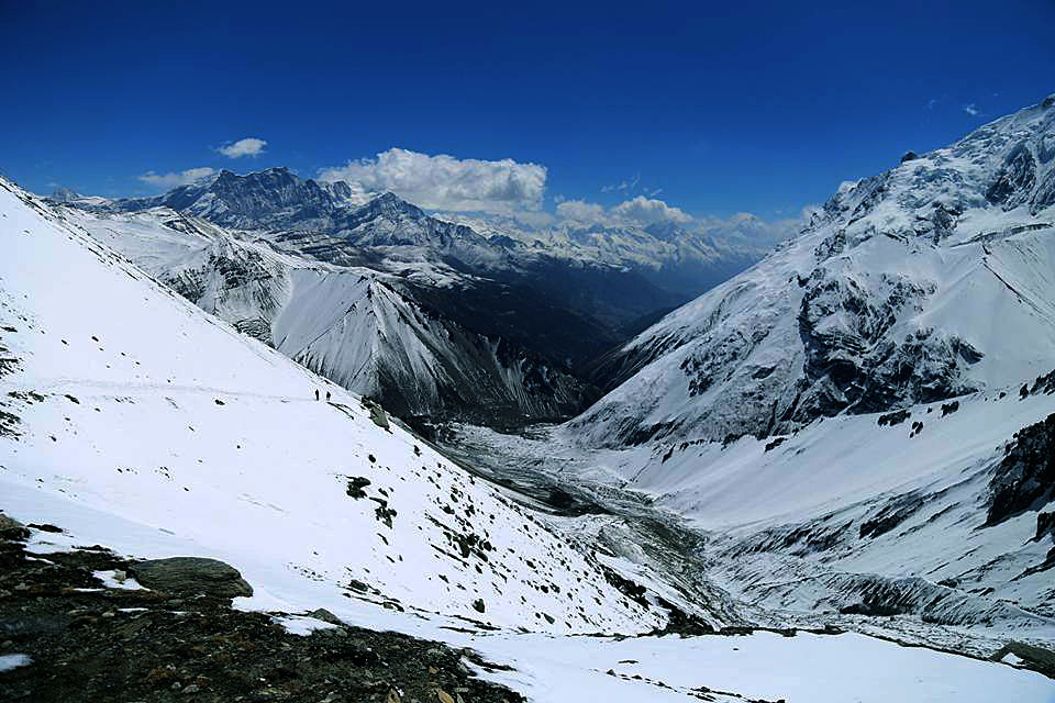
Day 10: Manang - Yak Kharka (4105m / 5hrs)
Fairly continuos uphill from Manang gaining about 300m to Gunsang. From Gunsang the path is generally flat. At a crossing point of a small side stream between two mani walls (route deviates) great views of the south face of the Chulu massif were had. After regaining height lost crossing the stream the route gently undulates while gaining the remaining altitude before arrival at Yak Kharka (means Yak Pasture).
-
Day 11: Yak Kharka - Thorang Phedi (4420m / 3hrs)
Fairly constant upward route until just before Phedi where one descends perhaps 150m to the braided river bed before climbing back up to Phedi. This is the end of the line, the source area of the Marsyandi River. Several small streams run out from deep gorges in the vertical limestone cliffs and converge in a broad braided river plain.
-
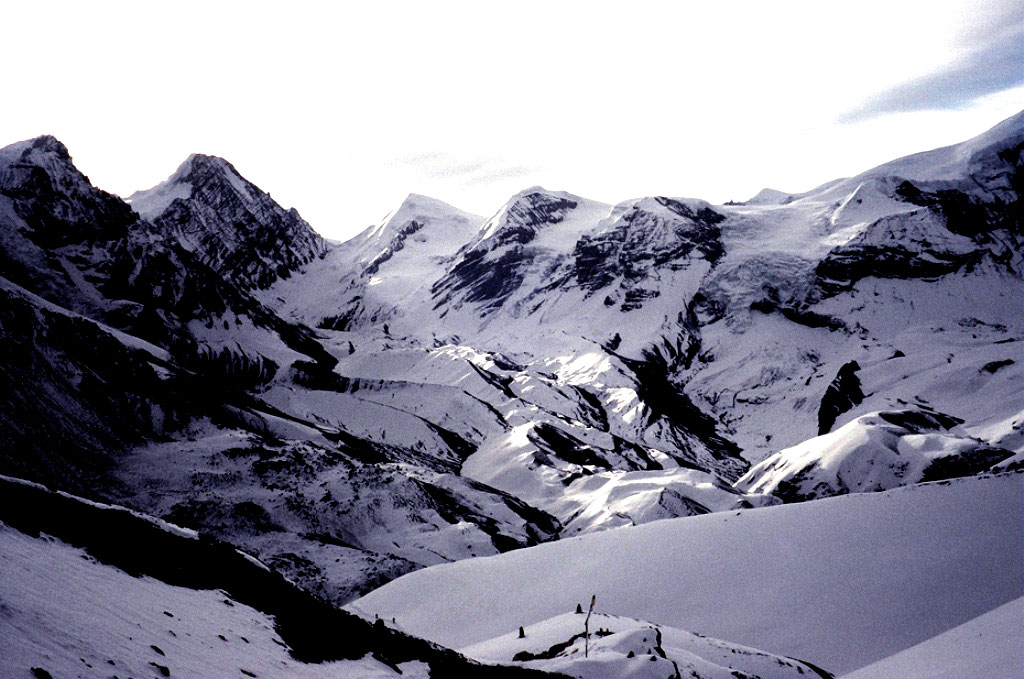
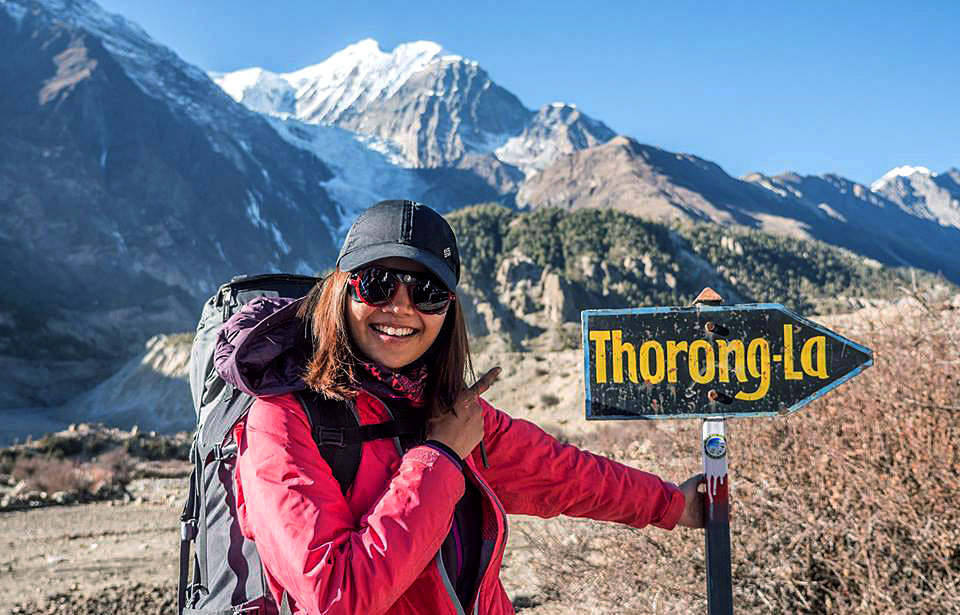
Day 12: Phedi - Muktinath (3800m), across the Thorung La (5416m / 8hrs)
Total ascent 895m, total decent 1815m. Big day!! We ascend steeply to a 4590m, then along an undulating trail to the flat top of Thorung La (5416m.) From here there are views of the Annapurna range to the south and Mukut Himal bordering Dolpo to the West. The trail descends steeply over glacial moraine, which gives way to grassy meadows before we reach Muktinath. This is one of the most important pilgrimage sights for Hindus. Holy water flows from the 108 carved spouts surrounding the Vishnu temple in a grove of poplars. Muktinath is also home to many ethnic Tibetans and holy Buddhists, who come here for the temple in which fire miraculously burns in a stream of water inside a small but very holy temple.
-
Day 13: Muktinath - Jomson (2713m / 5hrs)
Easy days walking down. Throughout the morning there are great views up the valley toward Muktinath and it’s Gompa, as well as the Thorung La. Sakya Gompa at Muktinath has lots of nice paintings outside and some very smartly painted drums etc. Walk down to Kagbeni for lunch (2.5 hours). The village is sat at the entrance to the Mustang valley and is separated from a steep cliff of vertical sedimentary rocks by the Kali Gandaki River. From the whole Mustang Valley down to Jomson the river runs down a shallow gradient forming a wide braided river plain, then another 3-hour walk to reach Jomsom.
-
Day 14: Jomsom - Kalopani (2560m / 5hrs)
Descend to Marpha, a lovely village of whitewashed houses and fertile fields. Continue down the Kali Gandaki reaching the old Thakali trading center of Tukuche. As the trail continues, the Himalayan rain shadow end and open spaces make way for coniferous forest and Kalopani (2560m.) From here there are spectacular 360-degree views of Dhaulagiri and the Annapurnas high above.
-
Day 15: Kalopani - Tatopani (1200m / 5hrs)
A beautiful walk, with another transition into sub-tropical vegetation and the return of water buffalo, banyan trees and poinsettias. The trail follows the river through a narrow gorge, and descends to cross a bridge near a spectacular waterfall, before winding through the valley to Tatopani. The hot water springs that give the village its name provide the perfect opportunity for a good ‘scrub.’
-
Day 16: Tatopani - Ghorepani (2850m / 6hrs)
Steadily climbing all day, we eventually leave behind the terraced fields and walk through thick rhododendron forest to the village of Ghorepani. We camp at the pass for the best views of the sunset over the spectacular, snow-capped Dhaulagiri and the Annapurna Range.
-
Day 17: Ghorepani –Poonhill (3180m/5hrs) –Nayapul & drive to Pokhara Overnight in hotel B/B
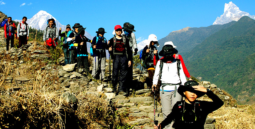
Trek from Ghorepani to Poon Hill (3180m.) to Tadapani (2675m.) which takes about five and half hours. Early morning trip to Poon Hill (3232m.) to enjoy the sunrise view over Mt. Dhaulagiri (8167m.), Tukuche Peak (6920m.), Nilgiri (6940m.), Varaha Shikhar (7847m.), Mt. Annapurna I (8091m.), Annapurna South (7219m.), Annapurna III (7855m.), Machhapuchhre (6993m.), Annapurna IV (7525m.), Annapurna II (7937m.), Lamjung Himal (6931m.) and other numerous snowcapped mountain peaks. After breakfast trek Ghorepani to ulleri .Today the trail undulates through giant rhododendron forest and orchid colonies to the pretty magar town of ulleri, then A steady climb down past startlingly green cultivated terraces and picturesque, beautifully-preserved farms to the Modi River, which the trail follows back to Birethanti. Drive to Pokhara, a big natural Beauty City out of Kathmandu, which is 200km from Kathmandu. Pokhara is a place of remarkable natural beauty. The serenity of Phewa Lake and the magnificence of fishtailed Machhapuchhre rising behind it make it an ideal setting to spend a few days in Pokhara.
-
Day 18: Pokhara – Kathmandu drive or fly.
After breakfast in the morning we say goodbye to Pokhara and head back to bustling Kathmandu by Tourist bus (There is an option to fly). In the afternoon free day of your own you can use this day for shopping.Overnight in Hotel.
In evening we will drive you to farewell dinner.
-
Day 19: Final Departure
All too soon it’s time to bid Nepal farewell and one realizes that we can never be intimate, only acquainted with this amazing adventure kingdom.
Tour Accomodation
Hotel Holy Himalaya in Kathmandu
Tea House while in Trekking
Hotel Pokhara View In Pokhara
What's Included
- Arrival/Departure
As per itinerary.
- Accommodation
Twin Sharing accommodation in 2 Star & 4 Star in Kathmandu & Pokhara with Breakfast.
- Transportation
Kathmandu to Pokhara to kathmandu in Tourist Bus/Flight. Pokhara / Besisahar and Birethanti / Pokhara Transportation.
- Permits
All necessary Permit during sightseeing and trekking.
- Guides/Porters
Escorted with English speaking guide during sightseeing and trekking. One Porter between two each two person during trek.
- Meals
Accommodation & 3 meals during tea house trek.
- Others
Food, accommodation, salary & insurance of guide and Porters.
- Insurance
Staff Insurance
- Farewell Dinner
Nepali Traditional Foods
- Certificate
Trip Success Certificate
- Airfares
International airfares
- Visa fees
Nepal Visa fee (US$ 40 per person for 30 days).
- Taxes and Charges
Airport Departure taxes/Excess baggage charges.
- Meals
Lunch/Dinner in Kathmandu and Pokhara.
- Insurance
Travel Insurance
- Medical Emergency
Medical evacuation in case of emergency.
- Personal Expenses
Personal spending money. Personal gears & clothing (available on hire) Tips, any expenses of personal nature, client's insurance Items of personal nature i.e. Soft/hard drinks, Tips etc.
- Others
Expenses incurred due to mishaps, landslide, strikes, political unrest etc. In such case extra will be charged as per actual.
- Tip
Tip for Staffs
Availability
| Start | End | Status | Price | |
| December 9, 2019 | May 23, 2020 | Available | USD $1090.00 | Book Now |
FAQ
-
Annapurna Round Trekking
Trip Duration: 19 days
Grade: Moderate
Max. Altitude: 5416m
Trekking: Teahouse
Accommodation: 2 nights in Kathmandu, 1 nights in Pokhara & 15 nights in trekking lodge
Transportation: Tourist Bus & Private car
Group Size: 2 to 30 Pax
Related Tours

Annapurna Base Camp Trek
USD $700.00 Per person
Learn More

Poon Hill Trek
USD 550.00 per person
Learn More